


 10:58 AM
 Hoàng Phong Nhã

(Được thông qua trong kỳ họp thứ 100 của Ban Thường Trực Quốc Hội Nhân Dân ngày 4 tháng 9 năm 1958)
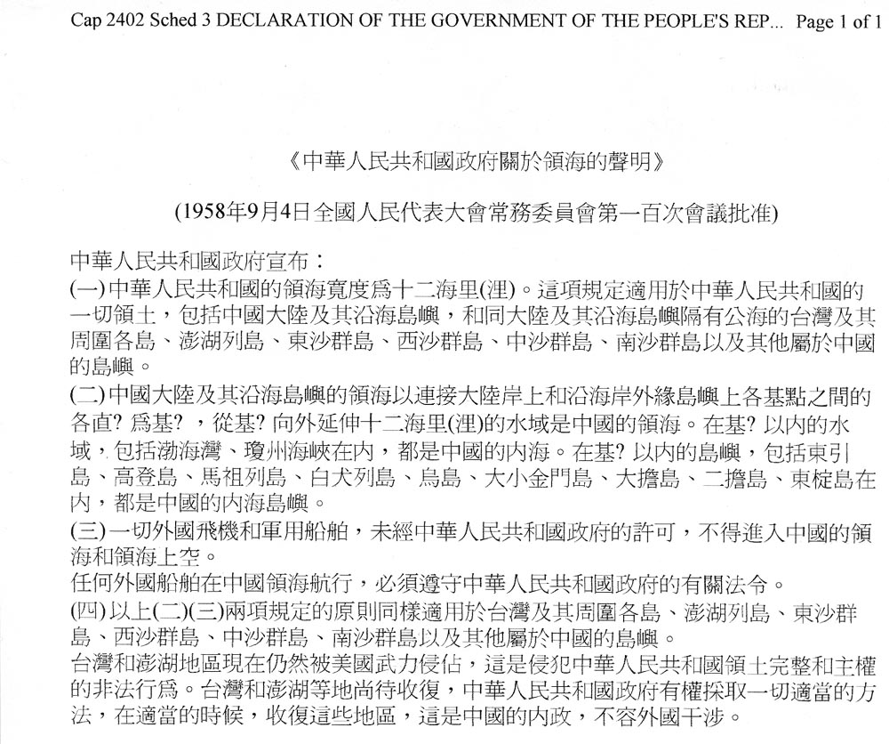
| Bản dich tiếng Anh Declaration of The Government of The People's Republic of China on the Territorial Sea (Approved by the 100th Session of the Standing Committee of the National People's Congress on 4th September, 1958) The People's Republic of China hereby announces: (1) This width of the territorial sea of the People's Republic of China is twelve national miles. This provision applies to all Territories of the People's Republic of China, including the mainland China and offshore islands, Taiwan (separated from the mainland and offshore islands by high seas) and its surrounding islands, the Penghu Archipelago, the Dongsha Islands, the Xisha islands, the Zhongsha Islands, the Nansha Islands and other islands belonging to China. (2) The straight lines linking each basic point at the mainland's coasts and offshore outlying islands are regarded as base lines of the territorial sea of the mainland China and offshore islands. The waters extending twelve nautical miles away from the base lines are China's territorial sea. The waters inside the base lines, including Bohai Bay and Giongzhou Strait, are China's inland sea. The islands inside the base lines, including Dongyin Island, Gaodeng Island, Mazu Inland, Baiquan Island, Niaoqin Island, Big and Small Jinmen Islands, Dadam Island, Erdan Island and Dongding Island, are China's inland sea islands. (3) Without the permit of the government of the People's Republic of China, all foreign aircrafts and military vessels shall not be allowed to enter China's territorial sea and the sky above the territorial sea. Any foreign vessel sailing in China's territorial sea must comply with the relevant orders of the government of the People's Republic of China. (4) The above provisions (2) and (3) also apply to Taiwan and its surrounding islands, the Penghu Islands, the Dongsha Islands, the Xisha Islands, the Zhongsha Islands, the Nansha Islands and other islands belonging to China. Taiwan and Penghu are still occupied with force by the USA. This is an illegality violating the People's Republic of China's territorial integrity and sovereignty. Taiwan and Penghu are waiting for recapture. The People's Republic of China has rights to take all appropriate measures to recapture these places in due course. It is China's internal affairs which should not be interfered by any foreign country. Trích từ nguồn: http://law.hku.hk/clsourcebook/10033.htm |
Bản dich tiếng Việt Tuyên Bố của Chính Phủ Nước Cộng Hòa Nhân Dân Trung Quốc về Lãnh Hải (Được thông qua trong kỳ họp thứ 100 của Ban Thường Trực Quốc Hội Nhân Dân ngày 4 tháng 9 năm 1958) Cộng Hòa Nhân Dân Trung Quốc nay tuyên bố: (1) Bề rộng lãnh hải của nước Cộng Hòa Nhân Dân Trung Quốc là 12 hải lý. Điều lệ này áp dụng cho toàn lãnh thổ nước Cộng Hòa Nhân Dân Trung Quốc, bao gồm phần đất Trung Quốc trên đất liền và các hải đảo ngoài khơi, Đài Loan (tách biệt khỏi đất liền và các hải đảo khác bởi biển cả) và các đảo phụ cận, quần đảo Penghu, quần đảo Đông Sa, quần đảo Tây Sa, quần đảo Trung Sa, quần đảo Nam Sa, và các đảo khác thuộc Trung Quốc. (2) Các đường thẳng nối liền mỗi điểm căn bản của bờ biển trên đất liền và các đảo ngoại biên ngoài khơi được xem là các đường căn bản của lãnh hải dọc theo đất liền Trung Quốc và các đảo ngoài khơi. Phần biển 12 hải lý tính ra từ các đường căn bản là hải phận của Trung Quốc. Phần biển bên trong các đường căn bản, kể cả vịnh Bohai và eo biển Giongzhou, là vùng nội hải của Trung Quốc. Các đảo bên trong các đường căn bản, kể cả đảo Dongyin, đảo Gaodeng, đảo Mazu, đảo Baiquan, đảo Niaoqin, đảo Đại và Tiểu Jinmen, đảo Dadam, đảo Erdan, và đảo Dongdinh, là các đảo thuộc nội hải Trung Quốc. (3) Nếu không có sự cho phép của Chính Phủ Cộng Hòa Nhân Dân Trung Quốc, tất cả máy bay ngoại quốc và tàu bè quân sự không được xâm nhập hải phận Trung Quốc và vùng trời bao trên hải phận này. Bất cứ tàu bè ngoại quốc nào di chuyển trong hải phận Trung Quốc đều phải tuyên thủ các luật lệ liên hệ của Chính Phủ Cộng Hòa Nhân Dân Trung Quốc (4) Điều (2) và (3) bên trên cũng áp dụng cho Đài Loan và các đảo phụ cận, quần đảo Penghu, quần đảo Đông Sa, quần đảo Tây Sa, quần đảo Trung Sa, quần đảo Nam Sa, và các đảo khác thuộc Trung Quốc. Đài Loan và Penghu hiện còn bị cưỡng chiếm bởi Hoa Kỳ. Đây là hành động bất hợp pháp vi phạm sự toàn vẹn lãnh thổ và chủ quyền của Cộng Hòa Nhân Dân Trung Quốc. Đài Loan và Penghu đang chờ được chiếm lai. Cộng Hòa Nhân Dân Trung Quốc có quyền dùng mọi biện pháp thích ứng để lấy lại các phần đất này trong tương lai. Các nước ngoại quốc không nên xen vào các vấn đề nội bộ của Trung Quốc. Chú thích: Quần đảo Tây Sa (tên tiếng Tàu) = Quần đảo Hoàng Sa = Paracel Islands Quần đảo Nam Sa (tên tiếng Tàu) = Quần đảo Trường Sa = Spratly Islands |

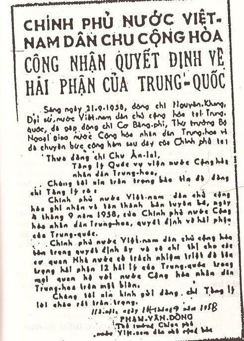 |
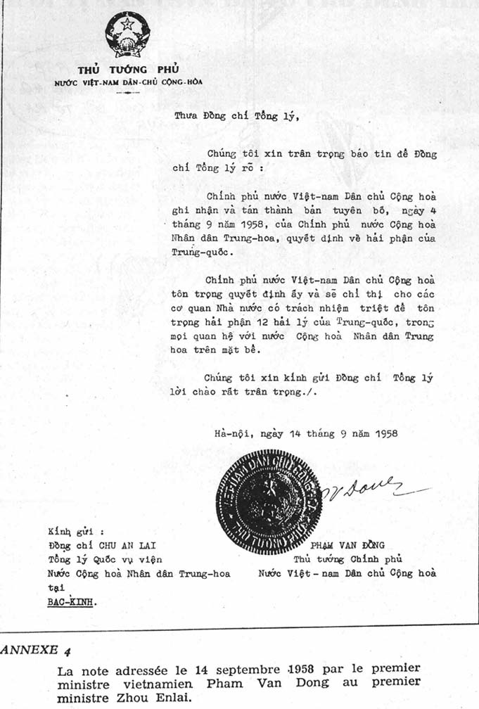
CHÍNH
PHỦ NƯỚC VIỆT NAM DÂN CHỦ CỘNG HOÀ CÔNG NHẬN QUYẾT ĐỊNH VỀ HẢI PHẬN CỦA
TRUNG-QUỐC
Sáng ngày 21.9.1958, đồng chí Nguyễn-Khang, Đại sứ nước Việt-nam dân chủ cộng hoà tại Trung-quốc, đã gặp đồng chí Cơ Bàng-phi, Thứ trưởng Bộ Ngoại giao nước Cộng hoà nhân dân Trung-hoa và đã chuyển bức công hàm sau đây của Chính phủ ta: Thưa đồng chí Chu Ân-lai, Tổng lý Quốc vụ viện nước Cộng hoà nhân dân Trung-hoa, Chúng tôi xin trân trọng thông báo tin để đồng chí Tổng lý rõ: Chính phủ nước Việt-nam dân chủ cộng hoà ghi nhận và tán thành bản tuyên bố, ngày 4 tháng 9 năm 1958, của Chính phủ nước Cộng hoà nhân dân Trung-hoa, quyết định về hải phận của Trung-quốc. Chính phủ nước Việt-nam dân chủ cộng hoà tôn trọng quyết định ấy và chỉ thị cho các cơ quan Nhà nước có trách nhiệm triệt để tôn trọng hải phận 12 hải lý của Trung-quốc trong mọi quan hệ với nước Cộng hoà nhân dân Trung-hoa trên mặt biển. Chúng tôi xin kính gửi đồng chí Tổng lý lời chào rất trân trọng. Hà Nội, ngày 14 tháng 9 năm 1958 PHẠM VĂN ĐỒNG Thủ tướng Chính phủ nước Việt-nam dân chủ cộng hoà |
Dưới đây là tai liệu do Bộ Ngoọi Giao Hoa Kỳ soạn thảo ngày 1 tháng 7 năm 1972.
STRAIGHT BASELINES: PEOPLE'S REPUBLIC OF CHINA
DocumentDeclaration on China's Territorial Sea
The Government of the People's Republic of China on September 4 issued the following declaration on China's territorial sea:
The Government of the People's Republic of China declares:
1) The breadth of the territorial sea of the People's Republic of China shall be twelve nautical miles. This provision applies to all territories of the People's Republic of China, including the Chinese mainland and its coastal islands, as well as Taiwan and its surrounding islands, the Penghu Islands and all other islands belonging to China which are separated from the mainland and its coastal islands by the high seas.
2) China's territorial sea along the mainland and its coastal islands takes as its baseline the line composed of the straight lines connecting basepoints on the mainland coast and on the outermost of the coastal islands; the water area extending twelve nautical miles outward from this baseline is China's territorial sea. The water area inside the baseline, including Pohai Bay and Chiungchow Straits, are Chinese inland waters. The islands inside the baseline, including Tungyin Island, Kaoteng Island, the Matsu Islands, the Paichuan Islands, Wuchiu Island, the Greater and Lesser Quemoy Islands, Tatan Island, Erhtan Island and Tungting Island, are islands of the Chinese inland waters.
3) No foreign vessels for military use and no foreign aircraft may enter China's territorial sea and the air space above it without the permission of the Government of the People's Republic of China.
4) The principles provided in paragraphs 2) and 3) likewise apply to Taiwan and its surrounding islands, the Penghu Islands, the Tungsha Islands, and Hsisha Islands, the Chungsha Islands, the Nansha Islands, and all other islands belonging to China.
The Taiwan and Penghu areas are still occupied by the United States by armed force. This is unlawful encroachment on the territorial integrity and sovereignty of the People’s Republic of China. Taiwan, Penghu and such other areas are yet to be recovered, and the Government of the People's Republic of China has the right to recover these areas by all suitable means at a suitable time. This is China's internal affair, in which no foreign interference is tolerated.

Peking NCNA in English Morse to Pyongyang at 1334 GMT September 4 also carried the statement of The Chinese People's Republic regarding establishment of a 12-mile limit in adjacent seas:
"2-China's territorial sea along the mainland and its coastal islands takes as its baseline the line comprising straight lines connecting basepoints on the mainland coast and those on the coastal islands on the outer fringe, and the water area extending 12 nautical miles outward from the baseline is China's territorial sea. The water areas inside the baseline, including the Pohai Bay and the Chuingchow Straits, are Chinese inland waters. The islands inside the baseline, including the Tungyin Island, the Kaoteng Island, the Matsu Islands, the Paichuan Islands, the Wuchiu Island, the Greater and Lesser Quemoy Islands, the Tatan Island, the Erhtan Island, and the Tungting Island are islands of the Chinese Inland waters."
The English Broadcast version said this in its final paragraph:
The Taiwan and Penghu areas are still occupied by the United States by armed force. This is an unlawful encroachment on the territorial integrity and sovereignty of the People's Republic of China.
Taiwan, Penghu, and such other areas are yet to be recovered, and the Government of the People's Republic of China has the right to recover these areas by all suitable means at a suitable time. This is China's internal affair, in which no foreign interference is tolerated."
Additional specific details on the PRC attitudes towards the law of the sea and the exploitation of the seabed are sparse. One major article, printed in Peking in 1959, conversations with foreign diplomats, ship incidents, "serious warnings" and "notices to mariners" constitute the principal source of our information on the subject.
Straight Baselines
Due to the non-specific language of the PRC declaration and of the Convention on the Territorial Sea and Contiguous Zone, which authorizes straight baselines, it is not possible to draft a single authoritative system for the mainland. The language is subject to interpretation. Moreover, the Convention, to which the PRC is not party, requires the printing of the lines on charts to which due publicity must be given. The two attached maps illustrate a system which, while hypothetical in many places, may be substantiated in documents and in practice. Further, it should be noted that all islands mentioned in the PRC declaration are either occupied by the armed forces of the Republic of China (ROC) or their sovereignty is disputed with other states. Many of these islands are so situated, however, that they indicate the PRC position toward the drafting of straight baselines.
Basically, Peking appears to have taken a realistic and non-expansive attitude in drafting its straight baselines. Rather than stating that the lines join the outermost points of the outer islands, the declaration notes that mainland points intervene. This decision would act to shorten the length of straight baseline segments and hence to diminish the claim to internal waters and to territorial sea.
Gulf of Pohai
Fu Chu wrote in "Concerning the Question of our Country's Territorial Sea", Peking 1959, that Pohai may be closed: 1) as a normal bay, 2) by straight baselines, and 3) by a claim to historic waters. According to the Convention on the Territorial Sea and Contiguous Zone, the first claim is out of the question because of the width of the bay mouth; the second represents a distinct possibility since the mouth is fringed with islands; the third point, however, goes to the heart of the matter. While the bay has not been listed in standard compilations of historic bays, geographically Pohai is totally enclosed by Chinese territory and the entrance would be completely enveloped by normal 12-nautical mile sea arcs. Fu Chu also notes that “if bays or gulfs have important interest with respect to the national defense and economy of the coastal states and for a long time the coastal states have repeatedly exercised jurisdiction over the bays or gulf, they may be regarded as historic bays.... The famous Gulf of Pohai, Hanchow Bay, Gulf of Chu River mouth are important internal bays of our country. The reason for mentioning the Gulf of Pohai in the Declaration on the Territorial Sea is that it is the largest bay ... of our country ... it has been constantly under the practical jurisdiction of our country and not only has our country always considered it as an internal sea, but also [such a fact] is internationally recognized. For instance, in 1864 when Prussia and Denmark were at war .... A Prussian gunboat Gazelle captured a Danish ship in the Gulf of Pohai, the then Chinese Government protests ... on the ground that Pohai is internal waters and compelled the Prussian Government to free the Danish ship."
He further stated that a 45-mile line would cJose the Gulf. The straight baselines represented on the attached map, which connect the islands by the shortest possible segments, measures very nearly 45 nautical miles. It must be assumed that, since no other 45-mile line could be drawn, that the PRC Government intended to use the chain of islands as a natural closing line of the Gulf as a historic bay.
South China Sea Islands
The declaration of 1958 applies the straight baseline principle to the Tungsha (Pratas), Hsisha Islands (Paracels), the Chungsha (Macclesfield Bank) and the Nansha (Spratly Islands).
Pratas, under ROC administration, is a small atoll which does not tend itself to straight baselines.
Warnings against intrusions into claimed PRC territorial waters of the Paracels indicate that the straight baseline alignment shown on the attached maps is accurate in the north and east. However, the inclusion of Triton island (claimed by the PRC) with the system is not clear. In addition to Triton, South Vietnamese forces occupy Robert and Pattle islands in the Crescent Group of the western Paracels. These islands may be excluded from any system by the PRC on an adhoc basis.
Macclesfield Bank is a submerged feature which does not qualify as a basepoint.
The Spraty Islands, because of their small size and wide dispersion, defy any logical system of straight baselines. Since these islands are not normally occupied by the PRC, intrusions have not been protested except for the Philippine occupation of Nanshan, Thitu, and Flat islands. ROB forces have been in charge of Itu Aba. A straight baseline system has no basis in fact
The straight baseline system of the PRC, if it were in fact drawn as indicated on the attached charts, could be subject to protest by the United States Government- the U.S. would certainly object to any mid-oceanic archipelago lines on the grounds they could interfere with navigation. The United Kingdom, which protested the straight baselines shortly after they were declared, has subsequently drawn its own system. Presumably the U.K. would no longer object to reasonable straight baselines drawn by the PRC. With the exception of the Spratly Islands, the straight baselines shown on the attached charts would probably be quite consistent with international state practices. However, the possibility exists that the PRC may have drawn loner straight baselines than have been indicated. These longer lines would include a much higher ratio of water to land within the baselines and might not, as a result, be viewed as acceptable.
 Posted in: Tranh chap Bien Dong va chu quyen cua Viet Nam
0 comments:
Post a Comment